


Relentless wildfires have continued to rapidly grow across parts of northeastern Minnesota north of Lake Superior, destroying at least 144 homes and buildings, after days of unseasonably high temperatures and low humidity.
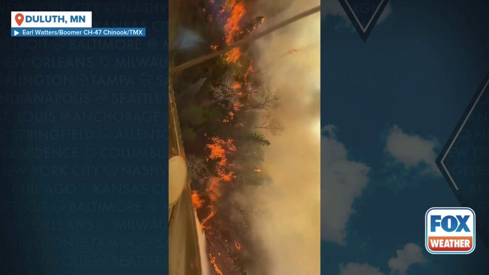
ST. LOUIS COUNTY, Minn. – Relentless wildfires have continued to rapidly grow across parts of northeastern Minnesota north of Lake Superior, destroying at least 146 homes and buildings, after days of unseasonably high temperatures and low humidity.
A trio of fires burning in St. Louis and Lake counties have scorched tens of thousands of acres, and evacuations remain in effect.
Minnesota Gov. Tim Walz activated the state’s National Guard on Monday to help with fire suppression.
SIGNIFICANT HEAT WAVE EXPECTED ACROSS TEXAS COULD BREAK ALL-TIME MAY RECORDS
Air quality alert issued due to wildfires
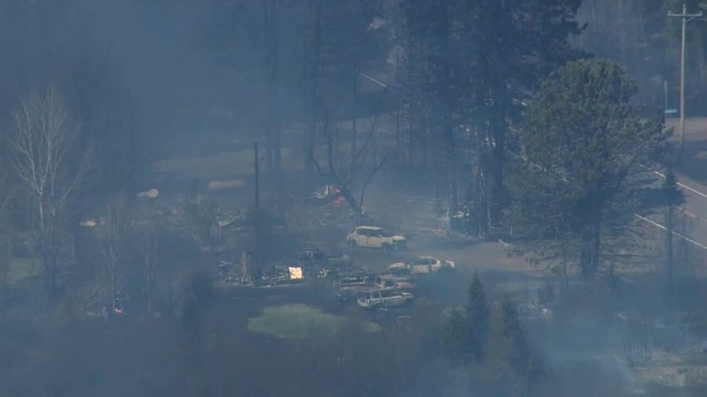
The Jenkins Creek fire has now engulfed more than 20,500 acres and remains uncontained, according to Minnesota Incident Command System (MNICS). The fire had consumed an undetermined number of buildings as of Wednesday afternoon. The St. Louis County Sheriff said in a social media post that the fire was too active to determine an accurate number.
The Camp House Fire, also known as the Brimson Fire, jumped to nearly 15,000 acres, MNICS reported. Local officials said that the fire has consumed 146 buildings and counting, mostly along Highway 44, which has been shut down in some places. That fire remains uncontained as well.
A third fire in the area, the Munger Shaw Fire, also called the Three Lakes Fire, has burned 1,700 acres, according to MNICS. Buildings have also been destroyed in the Munger Shaw Fire, but the sheriff said the number is undetermined.
The Minnesota Pollution Control Agency extended an Air Quality Alert for most of northeastern Minnesota through Wednesday.
OLYMPIC SWIMMER PRESENTED REPLACEMENT MEDALS FOLLOWING LOSS IN CALIFORNIA WILDFIRE
Wildfires have exploded in size across parts of northeastern Minnesota north of Lake Superior, destroying at least 40 homes and buildings, as unseasonably high temperatures and low humidity will continue to drive dangerous fire weather on Tuesday (Video Credit: KMSP).
Severe weather set to blow through Minnesota Thursday
It will be a busy several days for western Minnesota and the northern Plains as wildfire relief will eventually come in the form of severe weather and a flash flood threat.
According to the FOX Forecast Center, a strong upper-level disturbance emerging from the West will set the stage for a severe weather event across parts of Minnesota from late Thursday into Thursday night.
The most meaningful rain will be to the west of the areas currently battling wildfires, but showers and thunderstorms will still bring some overall relief to the region. A strong severe weather threat looms for central and southern Minnesota on Thursday with NOAA’s Storm Prediction Center issuing Level 2 and 3 risks across the heart of the state, with dangers for strong tornadoes, large hail and damaging wind.

(FOX Weather)
The areas north of Duluth where the largest fires are burning are north of the main threat area, but are still at risk of scattered strong showers and thunderstorms.
CHICAGO, DETROIT, INDIANAPOLIS FACE SEVERE WEATHER THREAT AS DANGEROUS STORMS EYE MIDWEST THIS WEEK
Flood threat expands into eastern Dakotas, Minnesota by Thursday
The backside of the cold front that will bring severe storms will also provide much-needed rain to areas being scorched by wildfires.
A prolonged period of moderate rain is expected, but a corridor of heavier rain is expected to shift into eastern North Dakota and northern Minnesota by Thursday.
NOAA’s Weather Prediction Center has issued a Level 1 out of 4 flash flood threat covering Wednesday and Thursday for parts of North and South Dakota.
WHAT IS FIRE CONTAINMENT?
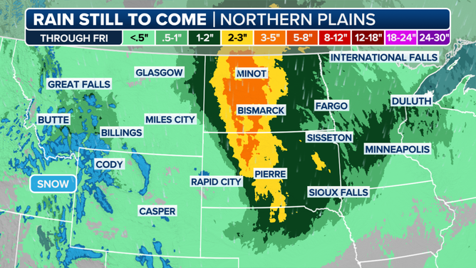
This graphic shows the expected rain for the Northern Tier through Friday, May 16, 2025.
(FOX Weather)
Editor’s note: This story has been updated to correct the name of the Jenkins Creek Fire.