
A historic satellite survey has found a disturbing trend among 28 of the US’s largest cities, such as New York, Chicago, Dallas, and Denver. Scientists from Virginia Tech employed the latest in radar imaging to map land subsidence, a slow sinking of the ground. Their results indicate that these large urban centers are sinking between 2 and 10 millimetres (0.08 and 0.4 inches) a year. This shocking find reveals the effect of processes such as groundwater loss, urbanisation, and natural geology, causing long-term threats to infrastructure, property, and inhabitants in such busy urban areas.
US populated cities are sinking, satellite study finds
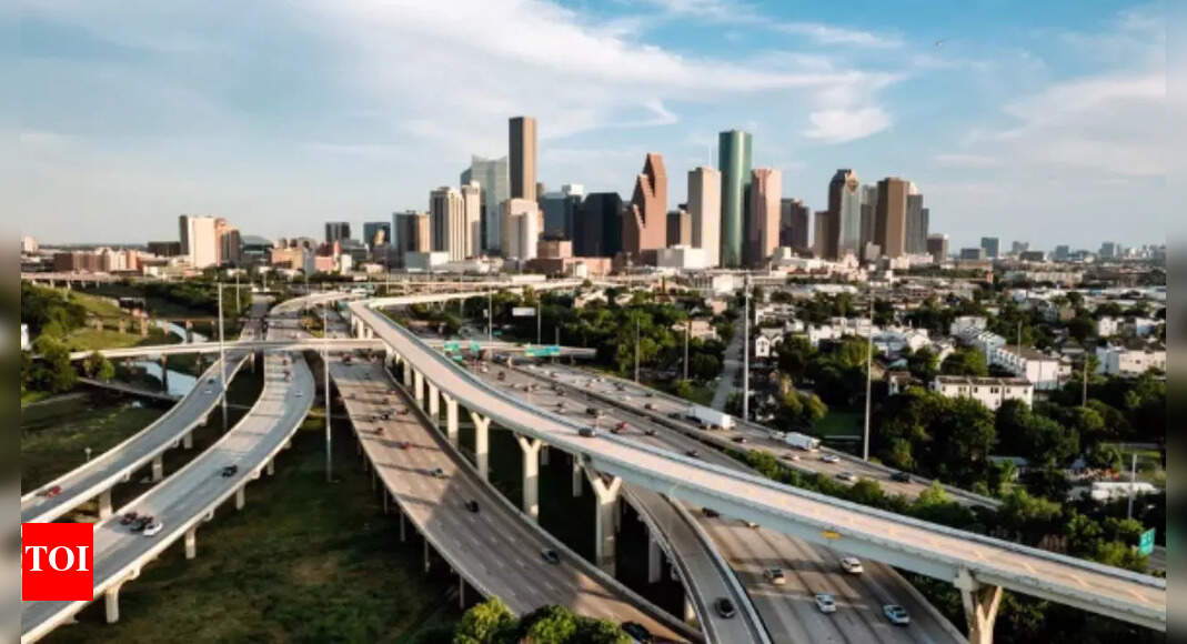
The research released in Nature Cities on May 8, it points to the extent and prevalence of the problem. In every one of the 28 cities examined, more than 20% of the area is showing apparent sinking. Most concerningly, in 25 of the cities, more than 65% of the ground is experiencing quantifiable subsidence, threatening long-term danger to infrastructure, city planning, and public safety.The most extreme subsidence rates were shown by Texas cities, with Houston being the most affected. In accordance with the research, about 40% of Houston is subsiding at rates higher than 5 millimetres per year, and 12% of Houston subsides at rates quicker than 10 millimetres per year.The study’s lead author, Leonard Ohenhen, and colleagues were able to link nearly 80% of this land subsidence to groundwater over-extraction. When urban populations increase, water demand increases—prompting municipalities to draw water from underground aquifers in unsustainable quantities. Ground depression follows as the soil structure is weakened by the extraction. Geological processes do have a role, but in most areas, the research confirms that human activity has emerged as the leading cause of the ground movement.
Experts warn slow land sinking quietly damaging infrastructure over time
Land subsidence experts warn that its creeping tendency tends to let the issue quietly progress without alerting anyone until too late. Minor alterations in the earth’s surface over time can add up to compromise the structural soundness of roads, bridges, railways, pipelines, and buildings. Manoochehr Shirzaei, an associate professor at Virginia Tech and co-author of the report, warned, “This risk increases very slowly, wipes out the ground from beneath, and if catastrophes happen, very few know about it in its initial stages.” This problem is not limited to coastal communities. Inland cities—that are far from the seashore—are also growing with susceptibility. Depressions in the land in these cities intensify flood hazards, disrupt drainage processes, and complicate long-term transportation, utility, and housing development planning.
Satellite technology helps scientists detect early signs
Application of Interferometric Synthetic Aperture Radar technology helped scientists identify subtle vertical movement of the Earth’s surface on a vast spatial scale. While ground-based surveys are retrospective and retrospective, satellite monitoring offers continuous and high-resolution data collection, enabling the measurement of land deformation trends on a citywide level. This sophisticated satellite monitoring is vital in early identification to enable policymakers and engineers to react promptly before subsidence triggers critical structural failures or environmental impacts.
Steps to reduce the growing risk of land subsidence
While total prevention of land subsidence is unlikely, the research sets out a multi-faceted approach to mitigation. Central recommendations are:
- Increased satellite monitoring: Ongoing funding of high-resolution satellite imagery to track subsidence near real-time.
- Tighter groundwater controls: Legislative action to control groundwater pumping, particularly in urban and peri-urban contexts.
- Resilient infrastructure design: Integration of subsidence risk in the design and construction of key infrastructure to enhance longevity.
- Public awareness campaigns: Raising awareness among local communities and stakeholders regarding the causes and impacts of subsidence to promote more prudent groundwater usage.
Urban subsidence is a widespread but underestimated risk to cities in the US Although the issue may develop gradually, its consequences are severe and enduring. If it goes unaddressed, subsidence would be an unseen threat that subtly undermines the integrity and operability of critical infrastructure. This new study highlights the necessity for concerted action—bridging science, policy, and technology—to protect America’s urban future.Also Read | NASA’s James Webb Space Telescope captures images of unusual cloud formation on Saturn’s biggest moon, Titan